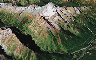
Fred, Steve, and Junko met us at the visitor center at 7:00. We got our permits, dropped off a car 8K down the road at Stone Arch, and were tromping up towards Hermit Meadows by 8:00.
On our previous trips we had always been too far to climber's left and lost time and elevation traversing back right over the rolling terrain to get below the big slope leading up towards Tupper. This time we forced ourselves to stay to the right at all costs and it worked out well. It helped that we could actually see for a change too!
This is Steve below

With a haughty cheer (not really) we crossed over the west ridge at around 12:30 and started down the other side of Tupper. Our first reward for perseverance was this great little slope. It was so nice that when Brenda reached the bottom she claimed that here smile muscles were sore

We traversed across some flats until right up against Tupper. From this point there is a long and very steep gully that leads down to two lakes. In this first photo we're heading towards the top of the gully. The second photo was taken later in the day and is looking back up at the gully which is just left of center.


Helluva run. One where you need to ski the whole thing in one fell swoop and then get the heck out of the way. We were all happy but knackered at end of it. From here with a mixture of contouring and then dropping down the fall line we eventually arrived back at tree line.
At this point there were two options available. The first is to continue descending down the same side of the ridge and to then contour around the end of the ridge and bushwack out to the highway. The second option is to ascend to the top of the ridge and to then cut across to the Connaught slide path which leads down to the railway and eventually to the car.
After checking the map and altimeter to make sure that we were in the right place we decided on the second option and started climbing up the ridge.

Oh man it took ages. The snow was riddled with depth hoar which sometimes made it seem more like swimming than climbing. Anyway we struggled to the top and back into the sunshine.
Steve points out roughly where the car is. Still a long way down.

We cut across to the slide path and spent a good long while assessing it's stability. Eventually we decided that all was well and, one at a time, down we went...
And down. And down. And then down some more. It was a long run. The snow, which began as really nice dense powder, first became slightly crusty, then diabolically crusty, and then at some point changed to full on wet spring-like snow. It was hard work.
After what seemed a really long time we hit the CPR rail line which was our guide back to the highway. In the second photo you can just make out the entrance to the famous tunnel which goes through Mount MacDonald. When talking with Luc at the visitor center he'd said "if it gets dark you'll know that you've hiked too far along the tracks".
Edit March 2013:
This post is getting a few views lately. Where do you people come from? Anyway I should note that our route along and across the rail tracks back in 2008 was acceptable (sort of) at the time but is strictly forbidden now. Here is a more recent post on the Tupper Traverse and proper exit instructions on the Parks Canada web site.


1550 meters of climbing and 9 hours car to car. Not too bad for a bunch of weekend warriors.


Hey Andrew
ReplyDeleteRight on looks like a big day.
I've been reading your BLOG all year. Great stories. great year.
Nick
Thanks Nick!
ReplyDelete