Saturday, February 18, 2012

Fidelity

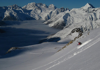
Last weekend we went exploring on Mount Fortitude Fidelity across from MgGill Shoulder at Bostock. This was the first time we had skied up this valley on the summer hiking trail. Usually we're traveling in the opposite direction at about mach 3 praying that there isn't a fallen tree across the trail around the next corner. At a slower pace it's a pretty place.


We skied to the head of the valley before turning west and heading up the first ridge north of Christiana.


By the time we climbed above the treeline the mist had come down and we couldn't see much. There were ccasional glimpses towards McGill Pass where we came out from the Three Pass Traverse last spring.

We skied along the edge of the trees down into the basin south of the ridge. The storm snow was sloughing very fast and made us quite wary. There had been a long dry spell and the new was sitting on top of surface hoar or sun-crust or a combination of the two.


We put the skins on and climbed up the basin for another run. When we ran out of sparse trees to guide us in the flat light we gave it up and skied back down the long mellow run to the valley bottom. This is really just a broad avalanche path a lot like NRC Gully (and felt equally spooky).

Photo:Nick

Once at the bottom, instead of climbing back up to the hiking trail on the opposite side we tried to ski out along the creek. This was a really nice way to ski back to the road and much more pleasant than the hiking trail. Although I don't think it would go in low snow years.


A nice day out. There's a good amount of north facing terrain up there that might be worth a return trip later in the season.

Monday, February 06, 2012

Asulkan Hut

When we visit the Asulkan Hut we're pretty much assured that the weather will be spectacular. We just never know if it will be spectacularly good or spectacularly bad. (Although even spectacularly bad can still be amazing, if somewhat limited.) Anyway last weekend truly fell into the spectacularly good category; blue skies, calm winds, fresh snow, and good stability all combined for three days of great skiing.

Youngs Peak Headwall


Moon Rise over Youngs Peak


Farming


Rogers Pass remained in the clouds the entire time adding that special look to many of our photos.


It was our second trip to the hut this season, and possibly our last until next year, so I'm happy it was a good one. You know it's been a good trip when changing two outhouse barrels is a minor footnote to the weekend rather than the major talking point.

Sunday, January 29, 2012

Bombtram Mountain Coquihalla

Older or wiser? Another big storm put us off the drive to Rogers Pass this weekend. Instead we met Dave and Keith at the Bombtram Mountain trailhead west of the Coquihalla summit. Great name for a mountain; there is a tramway here that was once used to hoist up explosives for avalanche control.

We were surprised to discover that Dave, a stalwart proponent of all things telemark who practically taught me how to telemark ski in the backwoods of the Adirondacks, had chucked it all in and converted to a Dynafit setup. Is there a word that means "feeling a combination of condescension and envy"?

The route followed a steep and often narrow ridge bounded by a box canyon on it's north side. Deep loose snow over a hard rain crust made for slow travel on the steeper sections. We exited from the trees into a wide expanse of open terrain with loads of potential for skiing. However it was blowing like made and we couldn't see much so chose to simply ski straight down through the trees from a point on the ridge well below the summit.


Really good skiing. So good that we were tempted into dropping further and further down from the ridge towards the rim of the canyon. Marked on the map is a narrow gully that provides the only way through the steep cliff bands. With the map and GPS we made our way to what we hoped would be an obvious entrance. Instead we found several options all of which looked possible but highly committing.


We hunted around for a while but it was too late to make the wrong choice and then have to climb back out again. Instead we put the skins on, climbed up to the ridge, and skied out the way we had come. It was almost a headlamp job but not quite.

In retrospect I think we had been in right place but just didn't have enough time to properly explore. Here's a good trip report from a group that did find the gully.


Wednesday, January 25, 2012

Zupjok Peak Coquihalla

Was it a day for exploring? Or a day to just go somewhere familiar and do laps? There were about 25 cars at Falls Lake so Steve and I chose the explore option. We continued down the road to the Needle Peak pull off, slapped on the skis, and headed west along a logging road towards Zupjok Peak.

The road loses quite a bit of elevation before beginning to climb upwards but this sad fact is more than made up for by the beautiful old growth forest it passes through. There were at least 2 to 3 metres of snow on the ground topped with several inches of nice light powder. We hoped for great things.

After a few map and GPS checks we got ourselves onto the thickly treed south ridge of Zupjok and began climbing in earnest. Our rough idea was to climb up the south ridge of Zupjok and then descend the east ridge to a col and then find our uptrack on the way down.

It started to snow heavily and as we got higher and the wind really picked up. By the time we neared the summit the snow was blowing horizontally; it stung our faces and reduced the visibility to just about zero.


Our mini traverse wasn't going to happen in these conditions. With regrets we turned around and headed back the way we had come. The snow was amazing but the trees were too tight for us to make the most of the great conditions.

At some point I broke a heel lift on one of my 7tm bindings. Freakin' tele bindings, there's always something. Half the reliability of an AT binding at twice the weight. Another step on the dark and inevitable descent to Dynafit.

Oh well. Some days you win and and some days you lose. Always nice to be out. As consolation on the drive home we saw one of these amazing double-width snow plows.

Wednesday, January 18, 2012

Illecillewaet and the Practise Slopes

Last weekend Brenda lead a trip for the ACC based out of the Wheeler Hut in Rogers Pass. The trip was for beginners who hadn't done much backcountry skiing before. It made for a very diverse group and some challenging group management throughout the two days of skiing. Brenda did a commendable job of making sure everyone had a safe and enjoyable couple of days, not to mention an awesome group meal on Saturday night. I think this photo sums up the evening pretty well.


About 25cm of light fluffy snow overnight made for a picturesque setting. We made forays up towards the Illecillewaet, near Lookout Col, and onto the Practise Slopes slightly down valley. It's simple terrain in terms of avalanche hazard but was a little bit intimidating for a few of the beginner skiers, especially with the so-so visibility, but I think everyone enjoyed their weekend.


Thursday, January 12, 2012

Thar and Nak Peak Coquihalla

We made an exploratory trip to the Coquihalla last weekend and did some skiing between Thar and Nak Peaks in the wide basin that faces the highway. The plan was to get to the col and check out the slope on the other side with the idea of doing a traverse down to Falls Lake one day. Unfortunately the visibility got really bad some 150 meters below the col and we gave it up, not too keen on wandering around blind in the unfamiliar terrain.


There's quite an expanse of open terrain up here just above tree line. We did a couple of laps on the road side and found some nice turns. There was a hard crust down about 20 to 30cm with fresh storm snow on top which made for some effortless skiing.

Conditions along the Coquihalla have been pretty hit or miss for us over the years but this was a good day.

Later on this week we learned that Loic was up in that area on the weekend too. He mentioned that he has skied off the other side towards Falls Lake before so we'll have to go back and give that a go one day.

Saturday, December 31, 2011

Lake O'Hara

A last minute hut booking, an overnight in Golden, and by 8:30am on Christmas Eve we were happily skiing along the road to the Elizabeth Parker hut in Yoho National Park. Happily, since this seemed wonderfully carefree compared with a similar trip we made at this time last year. It wasn't a thousand degrees below zero, it was daylight, we knew exactly where we were going, and it was only going to take a few hours.


Arriving by midday we chatted with a couple from Lake Louise before they departed and left us alone at the hut. Since we were expecting company (there were only a few spots available when we booked) we set up in the tiny Wiwaxy Cabin next door and went for a ski up to McArthur Pass. Returning at dusk to a still empty hut we stoked the fire, drank gallons of tea, put a serious dent in the wine, cheese, and cracker supply ("Skiing for cheesus!"), and just enjoyed a quiet Christmas Eve to ourselves.


On Christmas morning ours were still the only skis outside the hut. It was kinda weird.


A few small gifts exchanged, we skied over Mary Lake up to Opabin Plateau and Hungabee Lake. It snowed heavily for much of the day but there was surprisingly little snow on the ground in most places; it felt like Rogers Pass in early November. The potential for turns around here seems pretty limited.

Returning by Lake O'Hara I pointed out the peaks I had climbed here over the years, mainly with Ross, but also with Martin, Tim, and others. Brenda was very patient as I re-told the same stories that she has already heard a hundred times before. Like the time on Grassi Ridge when Ross lead a pitch that went way, way left from the belay. I watched him disappear from sight diligently clipping the left rope. Some time later he reappeared, directly overhead surprisingly, and much closer than expected considering all the rope he had out. Now he was forging a line way, way to the right and equally diligently clipping the right rope. By the time a shout of "on belay" came down from above and the ropes came taught I had two almost horizontal ropes leading away from my harness in opposite directions. Couldn't move an inch.

Grassi Ridge at center left behind the Elizabeth Parker hut


That evening we were joined by Yves, Katja, and Genevieve from Canmore, and Lauren and Rob from Calgary. We were glad for the company and they were such interesting people. Yves and Katja had recently finished a cycling trip from Mexico to Peru. Rob and Lauren are urban beekeepers among other things and had brought a bottle of fine mead with them. This helped ease the pain for poor Lauren who had begun the ski in rented AT boots. She was in so much pain by kilometre five that she had abandoned the boots and walked the remaining seven kilometres in her hut booties, towing a sled! We felt pretty boring compared to these guys.

An uneventful trip overall. It took us 4 hours to ski in from the road with full-on backcountry ski gear using wax rather than skins. Others on lighter cross country gear easily made the trip in 3 hours or less. Perhaps I'm too quick to judge but it doesn't really seem worth the trouble of hauling in heavy ski gear with the idea of getting some turns in this area. At the risk of stating the obvious Lake O'Hara is simply a stunning place to visit and well worth the short journey in winter.

Wednesday, December 21, 2011

Ursus Trees

A very snowy drive up to Rogers Pass on Friday night. It became especially interesting when the creaky old van decided that when switching from high to low beam it would just kill the headlights completely. Thank goodness we discovered this latest quirk along a relatively well lit section of the Trans Canada. Also for good measure the heater fan now only works when the head lights are turned on. Bad ignition switch? I dunno. Add it to the list.

We headed up to Ursus Trees with Gerald on Saturday morning.


It was cloudy and snowing quite hard throughout most of the day. Temperatures were just around freezing making the snow almost but not quite wet and getting pretty slabby where the wind was blowing.


Good skiing but we've spent so much in this area that we're getting a bit jaded. First world problems! We need to start venturing further afield but it's so tough this time of year when it's practically dark at 3:30. Oh well next time we're out the days will be just a few minutes longer.

Wednesday, December 14, 2011

Malakwa

Malakwa again on Sunday with Neal, Dan, Gerald, and John. The road was still in good shape but it's not clear if this is because it is still being plowed or simply because we haven't had much snow for a couple of weeks. The grader is still parked below 15k if that means anything.

We went up at 15k and over the top again. There was a nasty sun crust on the south side so we bailed half way down and spent the rest of the day on the road side. We explored some of the steeper lines off the ridge on skier's right of the main area. Good fun but it's starting to feel like we need more snow. No photos because...meh, same old.

Tuesday, November 29, 2011

Malakwa

We made another trip to Malakwa back on November 29th. Pretty late blog post and mainly just for my own records at this point.

There were only a few other vehicles at 15k and this might have had something to do with the rain crust that was lurking about 10cm below the surface, so we weren't expecting much as we reached the main summit. It was snowing hard and really windy. We had a pretty good run down the opposite (south-west) side and the crust wasn't too bad. By the time we had climbed back up it was a virtual white out. I'll admit that we got a little turned around on the top, wandering around in the howling wind trying to figure out where the heck our original uptrack was. In our defense we hadn't been up here for a few years. Anyway Nick pulled out his GPS in a manly "I'll save you!" manner and rescued us from further wanderings.


By now it had been snowing for a few hours and was beginning to pile up nicely. We had a couple of runs back on the north side before the short day caught up with us. Back at the car we finally crossed paths with Loic and Tess and friends. We've followed their blog for so long that it almost felt like we knew them even though we had never met before. Good to meet you guys!

A quick stop at the Burner for a Backhand and off for home.

This week (December 8th) we heard that the road would only be plowed to 6km beginning in December. I guess we'll find out soon enough.

Tuesday, November 22, 2011

Malakwa

We were very happy to be invited for a day of early-season skiing at Malakwa with Gerald, Neal, Neil, and Dan. The place was hopping, and it was exciting to run into a number of friends over the course of the day. There's something about running into people you know randomly, and especially in the mountains, that makes us feel generally good about life.

The skiing was still a bit early season, with some rocks and stumps showing through. Although our party did not suffer any damage to bodies or skis, there was much evidence of core shots and edge grinds in the tracks and exposed rocks.

Malakwa is a funny place - sometimes, when you least expect it, you find skiing nirvana. This time we angled for where we thought the lines were, but on balance came out a little short of the best the area has to offer. Still a super day though, with plenty of good turns.


We followed up with some food and beer at the Burner, which has seriously upped its game since we first went there maybe five years ago. Good food, good service - and still great beer.

Friday, November 18, 2011

Asulkan Cabin

Just another November weekend at the Asulkan Hut...


It's important to keep these traditions alive! No comparison to last year when we carried our skis for much of the journey in. This year we were up to our necks in snow at times...well, the tele skiers were anyway. Great snow, but all of it sitting on top of the buried surface hoar from last weekend. We had three significant skier remotes and also watched the Raven's avalanche path run almost full length.

Nevertheless we had a safe weekend, caught up with Dustin, hung out with yoga John and yoga Jeff, and shared the hut with a great bunch of guys from Vancouver.


Still no Brenda. I told her she didn't miss much. I don't think she reads this blog.

Sunday, November 06, 2011

Balu Pass

While Brenda was at a "conference" on a cruise ship in the Caribbean the rest of us had our very first turns of the season. It was a quick trip up to Balu Pass with a detour up into the lower reaches of 8812 Bowl. There was great coverage and people were skiing everywhere. 8812 was completely tracked out. We must have seen a dozen people come down off the north side of Cheops including a dog. Clanged a few rocks on the luge run out but overall a great start to the season. The one caveat being the surface hoar that developed over the weekend. When that layer gets buried I think we'll be hearing about in the avalanche forecasts for weeks.


Monday, October 31, 2011

Shuswap River

Edit June 2017:
Google pulled the plug on the Picasaweb photo service and the photos in this post will no longer click through to larger versions. If you're interested here's the full album on Google Photos: https://goo.gl/photos/PXwRtmM52n7NyAwk6


A few weeks ago we paddled another section of the Shuswap River. This time we started just below Mabel Lake at a convenient put-in called Brants Hand Launch. From here it was about 25km of paddling down to Trinity Bridge.


The first order of business was to remove all man-eating spiders from Steve's canoe.


Swaddled up in many layers against the cold damp morning, a few strokes got us away from the shore and very quickly we were heading downstream at a ferocious clip.


Perhaps a little too ferocious for my amateur paddling skills as we very nearly dumped crossing an eddy line trying to avoid a mid-stream boulder. The bow of the canoe was quickly swept upstream in the reverse flow of water. Our $200 garage sale craft heaved heavily onto her down stream side and perched there for a few sickening seconds before settling down with us pointed back in the direction we'd just come from. Anyway it gave us a good vantage point to watch Steve, Fred, and Junko slide smoothly past with a few feet to spare.

We had thought that the salmon run was pretty much over but in fact the river was heaving with fish. There were enormous Chinook salmon everywhere, thousands of bright red Sockeye, and also what we guessed to be Kokanee. At times the water would explode with fish, scaring us half to death. We saw dozens of Bald Eagles, occasionally seeing one swoop down to snatch a salmon from the river, and also what we think were several Golden Eagles as well. The Goldens were huge.


Around the mid-point of our journey the river widened, slowed, and began to meander back and forth. We paddled lazily along in the warm fall sun.


It took us about 6 hours to reach Trinity Bridge including a leisurely lunch break. We hand lined the boats around one tricky section but otherwise it was easy paddling. Portions of the river are certainly flowing quickly but it's straight forward and very accessible for the weekend warrior who is comfortable with short sections of almost white water. The lower section of the river from Trinity to Enderby is much calmer.

Monday, September 05, 2011

Matriarch-Macabre-Grimface Traverse

Update November 2017:
The photos in this post were hosted on Google's Picasa Web Albums. Google shuttered the service and these photos no longer click through to larger versions. Sorry about that. Here's a link to the album on Google Photos if you are interested: https://goo.gl/photos/a3a9bHEDswGkcNeg7


“Insanity: doing the same thing over and over again and expecting different results.” -Albert Einstein

For the third year in succession we were hiking up Wall Creek in Cathedral Park on the Saturday of Labour Day weekend. Our previous two trips had ended in cold, wet, ignominious defeat. Our cunning plan this time: there couldn't be an unforecasted blizzard on the same day for three years in a row. Actually that was our plan last year too...."Couldn't possibly happen twice in a row."

Anyway, late in the day, with the heavy packs beginning to weigh us down, we sure hoped for third time lucky. It was a nice hike with the late after afternoon sun angling sharply through the trees and the many wild flowers standing out brightly against the forest floor.


This time it took us 4 1/2 hours to arrive at the bivy site, a stunning location at the head of the valley.


As in previous years we were visited by some curious deer at dusk. They circled round our campsite closer and closer until within just a few metres of the tent. After we'd gone to bed we could still hear them padding around out there. Their steps sounded oddly human. It was bit spooky to be drifting off to sleep only to be jolted awake at the sound of footsteps just a few feet from our heads.

We got away early the next morning (no snow...yay!) and continued for a short while along the hiking trail before heading more or less straight up towards the gully and notch where the climbing begins. The scree is pretty crappy in the gully. Staying along the edges near solid rock offers the path of least resistance. This rather unimpressive photo gives a rough idea of where the notch is located.


It took us 1.5 hours to get to the notch where the climbing begins. From here "the route features perfect rock, high exposure, incredible views, and a variety of techniques including several rappels" to quote the good book and that pretty much sums it up. The first pitch is probably the best of the entire day; easy 5th class with a piece of gear or two above a tremendous drop down the other side of the ridge.
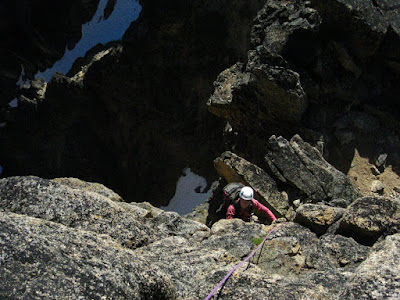


From then on we switched between scrambling, walking, short pitches of real rock climbing, a 5.8 variation, the odd piece of gear, rappelling into notches, climbing back out of notches...


The challenge was to be efficient with the rope without knowing what was coming up next. Ultimately the best solution was for each of us to take up coils with several meters between us. Then the rope was out of the way for most of the scrambling and we could drop the coils for short pitches or rapping when needed. The best part of the day was definitely the aid ladder which we'd read about. We were unsure if it still existed. Simply awesome.


Matriarch and Macabre passed by (not without snacks of course) and we were looking at Grimface shortly after midday.


Scraping our way under and over the big chockstones provided endless amusement as we scrambled up through the chimneys of the SE notch route. This first photo of Brenda shows most of the route in the background.


After what I'll call the "lower" chimneys we arrived at a gravelly notch just below the summit dome of Grimface. The rough directions we'd gathered online mentioned another chimney leading to the summit. We'd had enough by then, so instead we went to the right and followed an easy crack and corner system for 20 metres or so before cutting back left. We were on top at 2:00, 7 hours after leaving the tent, a bit longer than expected.

We didn't have a really good idea about the descent and made the mistake of relying on some directions we found online rather than following our own instincts. We followed a line of cairns that lead us towards the wrong gully. We sussed it out eventually. For anyone looking for descent info...just continue north along the ridge, bit of walking, bit of down climbing, until you come to the obvious (and I mean really obvious) wide scree gully about 30 minutes (?) from the top of Grimface. From the top of the correct scree gully you can see that it continues all the way down to the valley floor; you can practically see your tent. If you are looking down a gully that doesn't obviously descend unbroken to the valley floor, it's the wrong one.


Notes:
Drive to km 38 on the Ashnola River Road and begin hiking at a large wooden bridge. After approximately 1.5 hours keep right at a fork in the trail. ~800m elevation gain ~12km, 4.5 to 5 hours of hiking.

Gear:
We debated long and hard about what rope or ropes to use. In the end a single 50 metre 9mm was enough. The longest rap was pretty close to 25m. There was only one real pitch of climbing which was the first pitch of the day (plus the 10m 5.8 variation, the alternative being an easy chimney). The rest of the time we were short roping or carrying coils and slinging blocks for short belays. We had considered using two 30m ropes (keeping one in the pack and only breaking it out for the long raps). In retrospect I think this would have been a pain the butt. We had a light alpine rack but never placed more than 2 pieces of gear on any pitch. We used a medium 1.5-2" cam (on the 5.8 bit), a medium hex, and a #6 or #7 nut. We wore comfy rock shoes. Crossover climbing/approach shoes would have been a good alternative.

Times:
7:00am depart tent, 8:30 col, 10:08 Matriarch, 11:22 Macabre, 2:10 Grimface, 3:53 Tent

Other trip reports online here and here.

More photos over here on Picasa on Google Photos: https://goo.gl/photos/a3a9bHEDswGkcNeg7