Monday, December 31, 2012

Stanley Mitchell Hut

They say that a legitimate adventure has no predetermined outcome. To look at it from a slightly different angle, perhaps the idea of a true "adventure" has more to do with the nature of the participants than the actual objective itself. That's why our own humble definition of an adventure includes a visit to the Stanley Mitchell Hut during the short, dark, and cold days of late December. I mean it's not exactly hard core in the grand scheme of things right? But for us the promise of toasting our hands in front of a warm fire at the end of the day was never a sure thing until we actually laid eyes on the hut.

We did this trip a couple of years ago. I had never been so cold in my entire life. This time it was -18C for our 5:45AM departure from the parking lot. Not exactly balmy but considerably warmer than the -33C of last time.


Even so Brenda still had to break out the Backcountry Burka to keep her schnoz from getting frostbitten.


It took us over four hours to reach the shelter at Takakkaw Falls where we made some hot tea and refilled our thermoses.


There were a couple of pieces of firewood so we sparked up the ancient woodstove. It produced more smoke than heat but it did warm us up a little as we reapplied wax to the skis. We didn't see any sign of a larger wood supply. It would be a cold place to spend the night.


From the shelter we enjoyed the sun for a few kilometres before reaching the trees and beginning the true climb up into the Little Yoho Valley.


Finally reaching the hut at 3:30 we were pretty cold and tired but very happy to be there.


The next day we toured up towards Emerald Pass with Kevin, Brendan, and Jeremy from Calgary who we had met at the hut the previous night.


We even found some decent skiing in a steep little gully that had filled in with blowing snow.


This being New Year's Eve we celebrated in fine fashion with the Calgary Crew. As usual our own supply of booze was overshadowed by the massive quantities that everyone else had managed to haul in. There were even some fireworks to light up the midnight sky. Okay it wasn't quite midnight. We were all tired.


We closed up the hut the next morning.


And headed back home.


An adventure? Sure it was.

Monday, December 24, 2012

NRC

NRC is probably the most accessible bit of skiing real estate in Rogers Pass; straight up from the car and straight back down again. However we don't ski here very often. It gives us the heebie-jeebies. I really don't know if this feeling is justified or not since the place certainly gets skied regularly by a lot of other people. But whenever we're at NRC all I can think of is the several hours we'll spend skiing up and down a giant avalanche path. Anyway, with the good and stable conditions we decided that it would be a good day to visit NRC.

It was freezing cold and blustery and just plain nasty as we geared up in the parking lot just below the Rogers Pass summit. It didn't fill us with much hope for the day. But as we climbed the wind died and slowly but surely we began to leave the clouds below us.


A leisurely lunch was called for. We soaked up the sun and marvelled at the vista unfolding around us.


Cheops


After lunch we climbed up to around 2300m before finally pulling the plug as the snow become scoured and decidedly slabby. Some day I'd love to get to the top of this feature to look over towards the south side of McDonald. Skins off for the straight run back down to the car.

Brenda (Nick's photo)


Andrew (Nick's photo)


Nick on telemark gear. Who knew?

Sunday, December 23, 2012

Cheops North 5

Stability, visibility, powder: the rule is generally to pick any two. Magically, mystically, all three conditions aligned a couple of days before Christmas.

The north side of Mount Cheops sports a number of gullies dropping down into the Connaught Drainage. I think the lowest (The Hourglass) is #1 and the highest is #6 (not sure about that). Occasionally we've seen lines of tracks dropping down the higher numbered gullies. To us these 1000m descents have always looked really impressive and so intimidating.

Upper Cheops Gullies


But by now we had run out of excuses, so with the almost perfect conditions we finally had a go at what we think was Cheops #5.

Descent route


Up to Balu Pass we went, hung a left and struggled up the shallow faceted snow of the lower ridge before topping out on a broad plateau. There seemed to be at least two entrances. We took the first available and found our way easily into the upper bowl.

Nick just above the entrance


Having a good look at the entrance to #6 we decided instead to explore the less intimidating options further right.

Entrance to Cheops #6


The terrain opened up below us and we had a great look at the upper reaches of the descent.

Brenda with the descent route behind her


Wow! A fabulous leg-burning descent in a truly spectacular setting.

Nick


We were so happy to finally ski this line and felt privileged to have done it under conditions that didn't give us the heebie-jeebies. Okay there were a few heebie-jeebies but it wouldn't be a real adventure otherwise. That's the great thing about being average weekend warriors, we're easily thrilled!

Putting the skins back on after the run, a couple skied past on their way out. We overheard one of them exclaim "Holy cow! Look what those guys skied!". Whoever you were, thanks, you made our day!

Saturday, December 08, 2012

8812 Bowl

Brenda and I skied up Bruins Ridge and over into 8812 bowl on Saturday.

Balu Peak (Peak 8812)


It was a glorious winters day with a cold wind blowing across the ridge that chilled us to the bone. Is it this cold in January? I think the Okanagan climate is turning us soft. There were a few distinct narrow points along the ridge. I think it broadens out a bit later in the season. That or my memory is going.

Bruins Ridge


There were already several sets of tracks in the bowl. No one had gone all the way up to the pass yet so we made the extra effort to get up there and have a look over onto Bruins North.

Just below Bruins Pass


Four hours up and 15 minutes back down to the valley floor. Crazy.

Brenda


The fantastic light fluffy powder that billowed into our faces helped us to forget the time up to time down ratio. Not quite content with our day (okay one of us was content and the other one was already thinking about poutine in Revelstoke) we climbed back up to Balu Pass and up the other side of 8812 bowl for another run.

Another early season trip where the conditions were just as good as any that we find in midwinter.

Saturday, December 01, 2012

Malakwa Gorge

Up to The Gorge on Saturday with Dan, Neal, and a friend of Neal's. We all piled into Dan's truck for the drive up. At about 12k we hit a minor traffic jam caused by a very apologetic couple trying to get up in an AWD Acura with all season tires. She seemed a little spooked and said something about walking back down. We didn't pay much attention at the time but sure enough on the drive down we saw her tracks along the side the of the road for kilometre after kilometre.

In the process of shuffling vehicles around to get passed them, the cable for the release mechanism on Dan's emergency brake snapped with the brakes fully engaged. We all swarmed around under the truck trying to finesse a solution until Dan got bored, grabbed a tire iron, and twisted it around the break cable until it snapped with a loud ka-thunk! Problem solved. Almost. The truck thought that the emergency was still on and we had to tune out the incessant "ding-ding-ding-ding" of the warning chime for the rest of the drive.

It was an odd start to an odd day. The pull-out was packed with cars at 15km and it was very warm. Upon reaching the treeline we saw recent avalanche activity everywhere. There were 60cm crown lines all over the place. There was a buried surface hoar layer that was ridiculously reactive. Digging a quick hasty pit the layer popped out as we cut the back of the column with a ski pole.

Unwilling to venture higher we made a run back down to the road to find the parking lot half empty. After a leisurely lunch we took another short run and called it a day with pints back at The Burner.

Sunday, November 11, 2012

Asulkan Cabin

Our traditional first ski outing of the season. Ross, Fred, Steve, Nick, Brenda and myself. Also at the hut (along with 4 rascally poachers) was Team Vancouver from the same weekend last year. It was great to once again share the hut with these guys although their gourmet cuisine did make our own food seem somewhat meagre in comparison.


Poor Brenda developed the first hints of a cold the night before. By the time we were an hour beyond the trailhead she was barely able to place one foot in front of the other. We made (empty) offers to head back with her but she was determined. Her gear was divided up amongst the rest of us and Nick gamely strapped Brenda's pack onto the back of his own. She made it, then spent the next 48 hours flat on her back, trying her best not to be contagious.

We had great visibility this weekend and amongst other things followed Team Vancouver's excellent track up the Youngs Peak headwall and onto the summit. A first for us in November.


There was some great skiing on the lower Seven Steps area behind the Pterodactyl where it was protected from the wind. No surprise that there were still open crevasses and we didn't venture down the final step that leads below the tree triangle.


A super start to the season.

Sunday, September 23, 2012

Woolley and Diadem

Ross is secretly trying to climb all 54 peaks over 11,000' in the Canadian Rockies. This is news to Ross. He hasn't yet admitted the fact to himself. So perhaps "secretly" is the wrong word. It's more like he's coyly climbing the 11,000ers. Whatever, we certainly applaud his efforts since now he will look after the logistics and planning for whatever peak has most recently put a bee in his bonnet.

Update July 2019: Google killed Picasa. So the photos in this post don't click through to full size versions. Eat a dick Google. Here are the photos on Google Photos:
https://photos.app.goo.gl/cqFRhcEyJP4SXPS46

Woolley and Diadem are two such peaks. Given how accessible they are are, and how they can both be done in a single push, it was surprising that Ross hadn't dragged us here sooner. They are located on the west side of the Icefields Parkway just north of the Athabasca/Andromeda group. The plan was to do the 4 hour hike in on the first day, bivy, and climb the peaks the next day.

The first order of business was to cross the frigid Sunwapta River, thankfully only knee deep this late in the season, but still shockingly cold. We left our wet running shoes hanging in a tree to await our return.

Sunwapta River
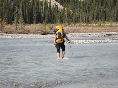

The bivy site is a barren spot but does have a certain stark beauty.

Bivy site


Our goal was to get up both peaks so we planned to take the line of least resistance to the Woolley-Diadem col and proceed from there. There are a few variations to get to the col. It doesn't look like it from the photo but the lower part of the glacier is threatened by serac fall from above so the obvious choice of heading straight up the left hand gully isn't a good one. Ultimately this was the route we followed:

Woolley (L) and Diadem (R)


One route description suggests climbing the toe of rock between the two obvious couloirs on Diadem before traversing left into the couloir adjacent to the glacier. We killed an hour investigating this option before giving it up. It was just a pile of loose shitty rock and in retrospect was a pointless endeavour when climbing the right hand gully and cutting across was so straightforward.

James at the point where we cut across to the left gully


From the col we made our way up the ridge of Woolley, broad at first, but narrowing in a few places where the late summer snow still lingered.


We had some mediocre views of Mount Alberta through the haze of forest fire smoke.

Mount Alberta


A quick lunch on top before retracing our steps back to the col to scramble up Diadem.

Descending Woolley. Diadem in the distance.


Heading up Diadem. Woolley behind.


Standing on the snowy top of Woolley it looked like there was a rocky sub-peak that was just slightly higher. Of course we now we had make our way across and scramble up this little pinnacle of rock to make sure.

James on the Pinnacle/ The first summit of Diadem just behind.


According to my altimeter the pinnacle was 1 metre lower. Doh. Back to the first summit, back to the col, and then back down the gully and across the glacier to the tents.

Descending the left gully. The tents are beside the lake below.
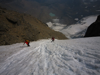

After relaxing in the sun beside the tents we decided to spend another night out.
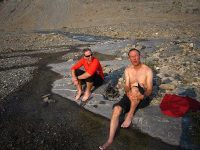


A fine, fine way for Ross to tick of two more coy 11,000ers.

Sunday, August 19, 2012

Eisenhower Tower

Edit June 2017
Google killed Picasa so the photos in this post don't click through to larger versions. Here's the full album if you're interested: https://goo.gl/photos/2LYxjhmyHPHoKgQ6A


Our original plan was to climb the east ridge of Edith Cavell with Brian. That idea got put on hold when a large chunk of the north glacier fell off wreaking havoc and closing access to the mountain for the rest of the season. (The first time I climbed Cavell I think we bivied right behind the outhouses in this photo.) So instead we set our sights on Castle Mountain to climb Eisenhower Tower, the three of us having climbed Brewer Buttress together in 2010.

Castle Mountain: Brewer in green, Eisenhower in red


After hiking up the Rockbound Lake Trail and skirting around ledges we arrived at the broad plateau which girdles the entire mountain. From here the first order of business is to get onto the Dragon's Back, a short crenellated ridge that juts out from the foot of the tower itself. We took a line just to climbers left of the prow and after a few easy 5th class moves we were scrambling along the top of this feature. It's quite spectacular in a few places.

Brian on the Dragons Back


Between the Dragons Back and the Tower is a deep notch with a short but tricky 5.6++ crack. We got the rope out here for the first time. After some grunting and groaning were up the other side just in time for second breakfasts and a good look at the route above where there are two main options.

Eisenhower Tower


I had climbed the left side before so this time we headed to climbers right. We didn't have any route description for this side and just kinda winged it. Unsure whether to keep the rope on or not we left it on and took turns running out it's full 60m length, slinging a few blocks along the way, and then bringing up both seconds at the same time. I think we did about 5 or 6 pitches.

Brian on the route


It felt much less travelled than I remembered the other side being. We came across one fixed anchor after the first pitch and nothing but the odd sling after that. I think there was more continuous climbing on this side but none of it was really exceptional. Nevertheless it's still a fine route to the top of a Rockies landmark.

Le Sommet


We had a good view at both the route we had just come up and also of the route we would be descending (in green) where there is a series of established rap anchors.

Routes


A couple of notes on the descent for anyone interested. The first anchor can be found by scrambling down below the crest of the plateau as in this picture where Brian (the lowest figure) is standing at the anchor.

First rap anchor


A bit of scrambling and another rap brings you to rap #3 (?) which is placed behind a fin of rock with an awkward start. If you rap to the end of the ropes here (we had a 60m) you end up in a tenuous spot to pull the ropes with some tricky downclimbing below. Instead, there is an intermediate 2 bolt anchor several meters to climbers right that looks like a much better option.

After some scrambling you end up at a "funnel" where all of the scree collects from the amphitheatre above. We made our way to the bottom of the scree and then followed an exposed but easy ledge to skiers left which placed us right at the top of P1.

Finally, rather than retracing our steps across the Dragons Back, we rapped down the east side of the notch which separates the Dragons Back from the tower. A 60m rope isn't quite long enough to reach the ground with one rappel. There is an intermediate anchor about 2/3 of the way down that is easy to miss.

In the end we somehow turned this into a 12 hour day which was a good 4 or 5 hours longer than we had anticipated.